With Roadway Reporter, you can configure mileage reports, format the report, save the report configuration, edit the report configuration, and run the report to produce either a CSV or PDF output.
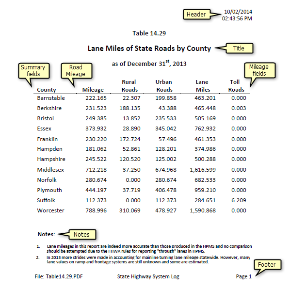
You can select a number of attributes from ArcGIS Roads and Highways linear event layers to report the mile count of those attributes summarized on up to three different summary fields. The following is an example of a mileage report that has been created using Roadway Reporter. The report has been configured to summarize road mileage by county, providing mileage for urban type (Rural Roads and Urban Roads), lane miles, and toll roads.

Examples of other types of mileage reports that you can configure include the following:
- Mileage of urban roads and rural roads summarized by counties and whether they are paved or unpaved
- Mileage of types of road surfaces, such as bitumen, asphalt, gravel, concrete, and so on, summarized by functional class
- Centerline miles, lane miles, and vehicle miles traveled (VMT), summarized by an administrative system
- Mileage of maintained public roads in each county, summarized by jurisdiction
- Lane miles and daily VMT by urban area
To create a mileage report, you can filter routes on which mileage is reported spatially, or by creating attribute filters. You can then choose the linear event layer attributes or LRS Network layer attributes on which to summarize mileage. You can filter these mileage attributes or create formulas from them. For example, if you want to report the mileage of routes paved only with concrete, you can filter your pavement type field to only count areas that are concrete. If you want to report against lane miles, you can create a formula to calculate lane miles that multiplies an event's length against a column in your number of lanes layer, which specifies the number of lanes on the road at various measure locations.